

Image source: Find A Grave memorial page for Robert Lewis Henry Sr. (1775–1844), Memorial ID 32232098; digital image of portrait photo, contributed by user HWA; photo edited by me
Robert Lewis Henry III (1775–1844) and his son, Robert Lewis Henry IV (b. 1800s), grandfather and father of Hiram Levi Henry, purchased 4 Illinois land patents between the years 1840-1849, in Versailles, Brown County, Illinois. A land patent is a government document, issued through regional land offices, granting ownership of a specific portion of public property to an individual purchaser.
When the land that is now Illinois became part of the United States, the government surveyed and divided the available land, using a standardized grid system. Each township measures 36 square miles, further divided into one-square-mile sections.
Early Brown County land patents reveal the Henry family’s settlement patterns in the early to mid-1800s, tracing their westward migration from Vermont and New York—and helping us fill in branches of the family tree.
Robert Lewis Henry III Parcels: 120 Acres, $150
- Accession Number: IL3990__.302
- Document Number: 6951
- Total Acres: 40
- Land Office: Quincy
- Place: Brown County, Illinois
- Meridian: 4th Principal Meridian – 1815 Illinois
- Township: 2 South
- Range: 2 West
- Section: 1
- Aliquot Description: SW¼ NW¼ (southwest quarter of the northwest quarter)
- Accession Number: IL3990__.303
- Document Number: 6952
- Total Acres: 80
- Land Office: Quincy
- Place: Brown County, Illinois
- Meridian: 4th Principal Meridian – 1815 Illinois
- Township: 2 South
- Range: 2 West
- Section: 1
- Aliquot Description: E½ NW¼ (east half of the northwest quarter)
Robert Lewis Henry IV Parcels: 120.56 Acres, $150
- Accession Number: IL4190__.190
- Document Number: 16829
- Total Acres: 80.56
- Land Office: Quincy
- Place: Brown County, Illinois
- Meridian: 4th Principal Meridian – 1815 Illinois
- Township: 2 South
- Range: 1 West
- Section: 6
- Aliquot Description: NE¼, Lot/Tract 2
- Accession Number: IL4210__.204
- Document Number: 17885
- Total Acres: 40
- Land Office: Quincy
- Place: Brown County, Illinois
- Meridian: 4th Principal Meridian – 1815 Illinois
- Township: 2 South
- Range: 1 West
- Section: 6
- Aliquot Description: W½ NE¼, Lot/Tract 1

Brown County, Illinois, Plat Maps
1903 Geo. A. Ogle & Co. Maps
The maps below are excerpts from the Standard Atlas of Brown County, Illinois, compiled and published by Geo. A. Ogle & Co., Chicago, 1903, which I modified for clarity. Versailles was (and still is) the south-eastern-most township in Brown County, bordered to the east by the Illinois River. The Henry land was located in the northeast corner of Versailles Township, near the river. Cooperstown and La Grange are to the north, and Cass County is to the east, across the river.
Note: these maps were created 50 years after the initial Henry patents were purchased, and the properties had changed hands by then. However, if you look closely, you will see “L. & M. Henry” in the north-east corner of Versailles Township.
- “L” = Lavina Henry, widow of Robert IV’s brother Asher Francis Henry
- “M” = Minnie (Henry) Wells, their daughter.
The patent for this land was purchased by Asher F. Henry in 1848. The Lavina Henry Cemetery in Versailles is the final resting place of 171 extended Henry family members, according to Find A Grave. There are a number of surnames represented and I haven’t placed all of them, yet. For now, here’s a quick post listing some of the Henry graves: Lavina Henry Cemetery in Versailles, Illinois


Early Federal Township Plat Maps
The U.S. Surveyor General’s Federal Township Plats are official plat maps of all congressional townships in Illinois, primarily drawn from federal surveys conducted 1804–1855, with additional plats from 1868–1891. Prepared by the U.S. Surveyor General’s office, these plats show township legal descriptions, sections, measurements, topographical and vegetation features, and occasional man-made and treaty boundary features.
Brown County Plat Maps
The U.S. Surveyor General’s early plat maps for Brown County—created from survey field notes recorded between the 1810s and 1850s—can be found here. I created a composite image by merging two of these maps and marked the approximate locations of the Henry parcels. Robert L. Henry III’s land is shaded blue, while the land of Robert IV and Mary Ann Langdon is shaded red.

Left side image: “Brown County, Township 2 South, Range 2 West, Section 1,” U.S. Surveyor General’s Records for Illinois: Federal Township Plats, Illinois State Archives; digital image, Illinois Digital Archives
Right side image: “Brown County, Township 2 South, Range 1 West, Section 6,” U.S. Surveyor General’s Records for Illinois: Federal Township Plats, Illinois State Archives; digital image, Illinois Digital Archives
Extended Family Patents
In addition to Robert L. Henry IV, four other sons of Robert III and Roxanna (Hayward) Henry were Brown County patentees:
- Orris Martin Henry (b. 1814- d. 1875)
- Asher Francis Henry (b. 1816- d. 1863)
- Hiram Asa Henry (b. 1817- d. 1884)
- Francis J. Henry (b. 1822- d. 1888).
Daughter Matilda (Henry) Adams lived right in the middle, with her husband Elisha Gillett Adams.
Another patentee, Jesse Langdon, was the father of Mary Ann (Langdon) Henry (wife of Robert IV and father of Hiram L. Henry).
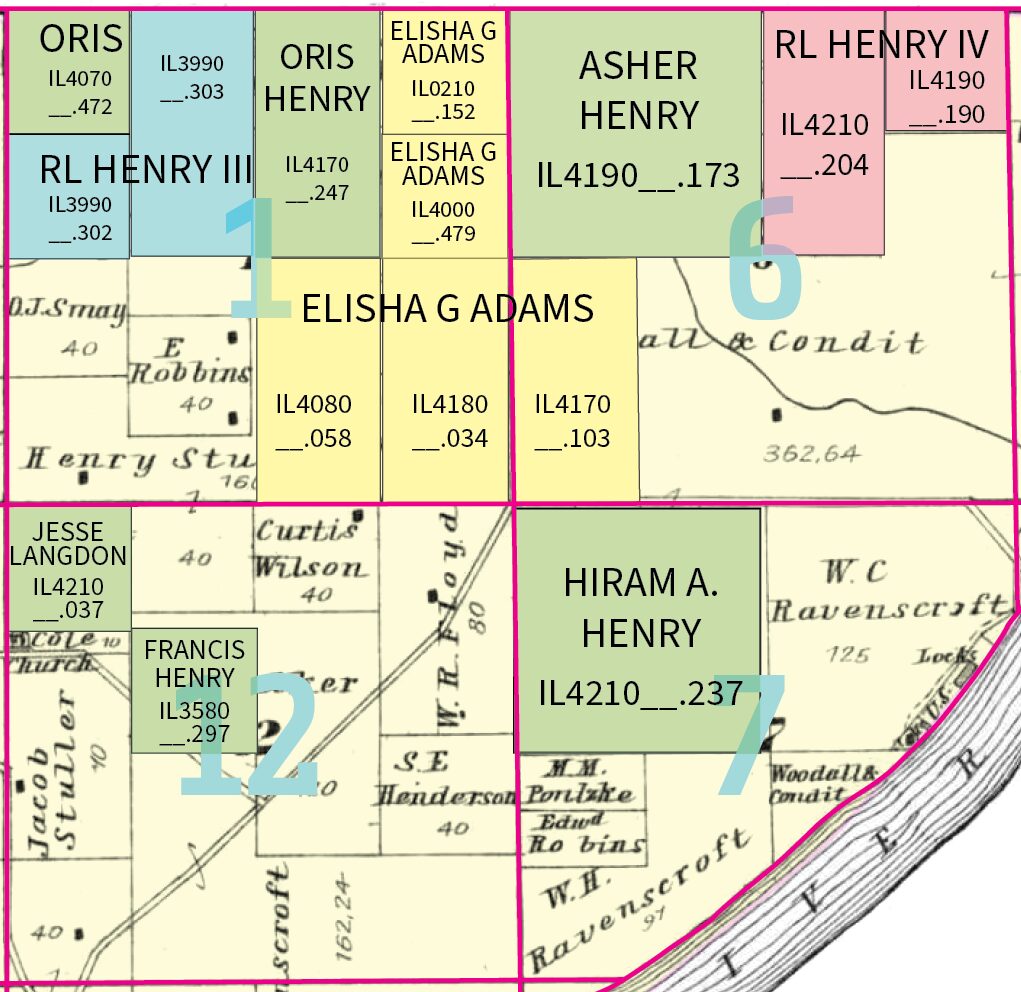
Henry surname patentees who I haven’t connected to the tree include: William, Milo, Jonathan Jr. and Lewis Henry.
Through these records, I’ve learned that while the Hiram L. Henry family scattered to the wind, several generations of his father and grandfather’s families (Robert Lewis Henry IV and III) migrated along the same paths and settled in very close proximity to one another
. Their settlements occupied a large portion of four sections of Township 2 South (Versailles).
Closest Neighbors
I used the US Bureau of Land Management, General Land Office (BLM GLO) Records search tool to comb through patentees adjacent to the township sections where known Henry land tracts were concentrated.
My initial search included all patentees within the four sections: Sections 6&7 in Township 2 South, Range 1 West; and Sections 1 & 12 in Township 2 South, Range 2 West. See the image “Henry Family Land Patents” for a visual of those sections.

United States, Bureau of Land Management (BLM) Tract Books
BLM Tract Books document the official history of public land parcels, from the time they were first surveyed until their transfer from federal to private ownership, typically between the years 1820-1955.

Modern Day Location Coordinates of Henry Land
For an approximate location you can use the following Google Maps locations to orient you:
- Southern-most point of boundary line between section 1 of T 2S, R 2W (contains Robert L. Henry III parcels) and section 6 of T 2S, R 1W (contains Robert L. Henry IV and Mary Ann Langdon parcel)
- Point most likely within boundaries of Robert L. Henry and Mary Ann Langdon parcel
- Point most likely within boundaries of Robert Henry Sr. parcel
Illinois Land and Property Resources
1838 Map of Illinois by T. G. Bradford (Published 1841)
“Illinois (U.S.), 1838,” Historic Maps, 1540–1942 (Lewis University, Romeoville, Illinois); engraved by G. W. Boynton; published in Samuel G. Goodrich, General Atlas of the World, with a Separate Map of Each of the United States of America (Boston, Penn., 1841); digital image, Lewis University, CARLI Digital Collections (https://collections.carli.illinois.edu/digital/collection/lew_map/id/39/rec/5 : accessed 2 August 2025); citing original map entered according to Act of Congress, 1838, by T. G. Bradford, in the Clerk’s Office of the District Court of Massachusetts.
1842 Map of Illinois by Jeremiah Greenleaf
Jeremiah Greenleaf, Illinois, map no. 46, detached from A New Universal Atlas (Brattleboro, Vt.: J. Greenleaf, 1842); digital image, Internet Archive (https://archive.org/details/illinois00gree : accessed 2 August 2025); from the Lincoln Financial Foundation Collection, contributed by the David Harts Collection of Illinois Maps; prime meridians: Greenwich and Washington.
Brown County Federal Township Plats (1810s–1850s)
U.S. Surveyor General, Brown County [Township Plat Maps], 1810s–1850s, U.S. Surveyor General’s Records for Illinois: Federal Township Plats; digital images, Illinois State Archives, via Illinois Digital Archives (https://idaillinois.org/digital/collection/IllinoisPlats/id/2584 : accessed 2 August 2025); citing original plats certified by the U.S. Surveyor General, showing township surveys, magnetic meridians, acreage calculations, and legal descriptions.
U.S. Surveyor General’s Records for Illinois – Federal Township Plats Collection
U.S. Surveyor General, Federal Township Plats, 1810s–1850s, U.S. Surveyor General’s Records for Illinois; Record Series 953.012, Illinois State Archives, accessed via Illinois Digital Archives (https://idaillinois.org/digital/collection/IllinoisPlats : accessed 2 August 2025); including plats for counties throughout Illinois based on survey field notes, delineating sections, acreage, and meridian variation.
United States, Bureau of Land Management Tract Books on FamilySearch
“United States, Bureau of Land Management Tract Books, 1800–c.1955,” entry for Robert S. Henry [indexed; appears as Robert L. Henry in image], 17 October 1848; database with digital images, FamilySearch (https://www.familysearch.org/ark:/61903/1:1:6K1P-8C3Q : accessed 3 August 2025); citing Illinois Quincy S and W, vol. 1, p. 4, image 12 of 755, Tract Books, Illinois, roll no. 44; Bureau of Land Management, Springfield, Virginia. Direct image link: https://www.familysearch.org/ark:/61903/3:1:3QS7-89W3-4NG.
